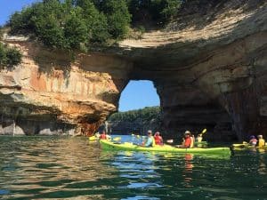
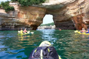
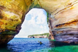
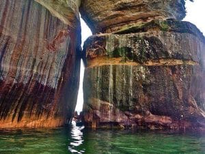
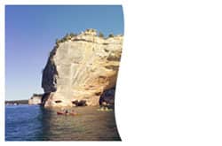
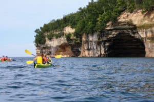
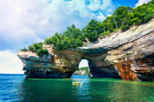
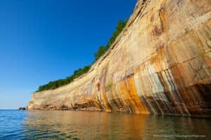
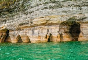
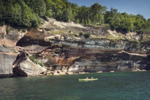
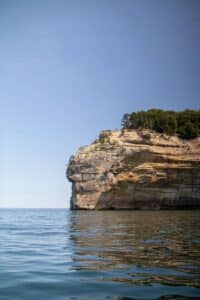
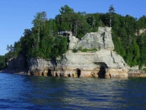
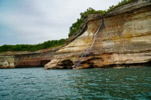
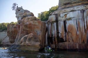
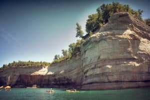
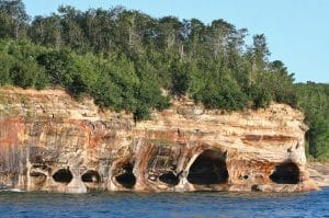
DISCOVER

PICTURED ROCKS

See All Pictured Rocks Has to Offer

Nestled along Lake Superior’s Southern shore in the middle of Michigan’s Upper Peninsula, Pictured Rocks National Shoreline is one of many attractions in the Munising area. From dappled sunlight hiking trails to cascading waterfalls, ancient rock formations to ice caves, there’s so much to see, do and experience in the UP! We want your Upper Michigan vacation to be packed with fun and memorable moments, so check out some of these amazing area attractions that you’ll want to visit while here.

Pictured Rocks National Lakeshore

Pictured Rocks National Lakeshore is a U.S. National Lakeshore on the shore of Lake Superior in the Upper Peninsula of Michigan. It extends for 42 miles along the shore and covers 73,236 acres ). The park offers spectacular scenery of the hilly shoreline between Munising, Michigan and Grand Marais, Michigan, with various rock formations like natural archways, waterfalls, and sand dunes.

Pictured Rocks derives its name from the 15 miles of colorful sandstone cliffs northeast of Munising. The cliffs are up to 200 feet above lake level. They have been naturally sculptured into shallow caves, arches, formations that resemble castle turrets, and human profiles, among others. Near Munising visitors also can view Grand Island, most of which is included in the Grand Island National Recreation.

Indian Head Rock

This gargantuan rock formation is named after what many say resembles an old ‘Indian Head’ carved into an impressive point of Pictured Rocks. The cliffs of Indian Head are nearly vertical walls from the Lake Superior to its peak. “Paddle and Hike Tour”

Rainbow Cave

The largest cave in the Pictured Rocks shoreline that features a large multi-colored copper stain as you kayak into it.

Bay Furnace

A short 1/8 mile accessible trail encircles the recently stabilized ruins of a blast furnace where pig iron was made between 1870 and 1877.  One of the last remaining structures of its kind in the Upper Peninsula, it is also a good place to view Lake Superior and Grand Island.

Grand Island

Grand Island stretches north for 8 miles, from its southpoint at Williams Landing in Munising Bay to the north end at North Point. Only three miles across at its widest point, Grand lsland offers 35 miles of shoreline, encompassing over 13,500 acres of dense woodland, including several lakes. Rapid-flowing streams cut through the rugged hills, and massive 300 foot wave-cut sandstone cliffs. Beaches of fine sand, winter ice caves and historic buildings and artifacts dating back as far as 2,000 BC are just a few of its highlights. Archeological investigations indicate that Grand Island has been inhabited for at least 3,300 years. In the 1660's, when the explorer priests arrived from France, the Ojibwa culture on Grand Island was already thriving.

Located only ½ mile offshore from Munising this island is 9 miles long and up to 3 miles wide with many beaches, sea caves, arches, cliffs, and wildlife abounds. Same geology as the Pictured Rocks.  The first Settlers came to the Island in the early 1800's when trading for furs was the prime industry. Evidence of this activity is still apparent there. The first permanent settlers arrived in 1846, setting up a trading post there to trade with the Ojibway Indians.

Miners Castle

Best sea caves in the Pictured Rocks Area. See this on the " Morning and Afternoon Delight Tours".

Bridalveil Falls

Tallest waterfall in Michigan- Seen on the Paddlers Choice, Paddle and Hike, and Taste of the Rocks Tours.

Kissing Rock

Guide your kayak through the tight crevice these two giant rocks form by "kissing" each other. It's a must see destination at Pictured Rocks!

Shipwreck Point

Ribs and keel of an unknown vessel that sank in the last century. Very visible from a kayak in about 10 feet of water.  “Taste of the Rocks” tour.

Mosquito River & Beach

This is where we normally take the lunch break on the “Paddlers Choice” and Paddle and Hike Tours. Great swimming here on some days. Short walk to observe the Lovers leap Arch and Mosquito Falls.

Lovers Leap Arch

The most photographed place in the Pictured Rocks. Fun to paddle through. Ask your guide about the Native American legend of how it was named. "Paddlers Choice" and "Paddle and Hike" tours.

Caves of the Bloody Chiefs

Local legend says the native American Tribes placed their prisoners of war here. Seen on the “Paddlers Choice” and “Paddle and Hike” tours

Grand Portal Arch

Was truly the most magnificent feature of the Pictured Rocks until rock collapses in 1900 and 1999 blocked the archway that sailing ships once traversed. ‘Paddle and Hike Tour.

Battleship Row

Unique rock formations that look like the sterns of a row of battleships. Located just prior to reaching Chapel Beach. “Paddle and Hike” tour

Chapel Rock

End Point of the "Paddle and Hike Tour. Note the roots from Chapel Tree extending through the air to the ground adjacent to it.

Falcon Cove

The vegetation on these cliffs attracts many Peregrine Falcons into this cove to nest and feed.  It also features a few smaller caves you can kayak into!

Painted Coves

Gaze up as you kayak through these coves with 200' tall sandstone walls gleaming with several different mineral stains in a variety of colors.

Miners Beach

This sugar sand beach is the starting point for all of our Pictured Rocks kayak tours.

Echo Falls

One of the tallest waterfalls on Grand Island that spills over the cliff edge and drops into Lake Superior.

Lower Potato Patch Falls

This little waterfall is named after where the first generation of loggers in the area kept their potato patch.

Chapel Falls

This waterfall is located on the chapel trail and can be seen on the Paddle and Hike tour as you hike out at the end of the day.

Flower Vase

Carved sandstone that is narrow at the water line and widens at the top with deciduous tree growing up resembling flowers in a vase, this rock along with many others were way points for the early Voyageurs as they made their way along the shores of Lake Superior during the fur trade.